All ABOUT LANGKAWI MAGICAL ISLANDS
What can you Expect while You are read of this website? A deep insight and practically Easy information about Langkawi U can get from this website and its tourism that are based on 10 Years of experience Guides & Driver in the island. So if you are a tourist planning to visit the island, you can plan and design a perfect vacation using this website. You don't need to look any further.
Langkawi is a jewel and a natural paradise in the whole of South East Asia. It's a cluster of 99 Malaysian islands and located off the western coast of peninsular Malaysia. Another 5 islands are submerged. However it's the main island (pulau Langkawi) where most tourists visit & stay. The emerald blue water and the lovely sunny beaches are dreams for the beach lovers and those who love watersport activities.
Langkawi has received The World Most amazing GEOPARK status from UNESCO on due to its magnificent geological landscapes & formations that are full of amazing limestone rocks, sea arches, caves, and fossils some of which are over 480 million years old. There are countless tourist attractions in the island including public beaches, waterfalls, mountains, parks & reserves, marine life, historical & heritage buildings, monuments, shrines, art & craft ... the list is endless.
And all this amidst charming and friendly people of the island. The island which is now a leading tourist destination in the world, offers plenty of top class hotels both for budget and luxury travelers, and numerous restaurants offering a range of food that suits every culinary taste.
This website is designed to guide you with all the above including top tours & attractions, recreational activities, shopping & nightlife, great hotels & restaurants, events & festivals, people & culture, island & travel information, and lot more. And all these along with pictures, maps and even videos!
So ready to explore Langkawi and all its offerings? Let's start...
Langkawi is not a single island. It is a cluster of smallx2 99 islands on Andaman Sea Around LANGKAWI in Malaysia and off the western coastline of Malaysia's mainland. Actually there are five more small islands that remain submerged and can sometimes be seen during low tide. And most of these islands that comprise Langkawi are real tiny and uninhabited. The main island which is known as Pulau Langkawi is the largest of all and the entire Langkawi cluster has been named after this one. Most of the residents live on this main island and visitors arrive here
Langkawi's main symbol is a reddish brown eagle. Why? Because the word Langkawi has been derived out of two local words. 'Lang' which comes from the word 'helang' meaning Eagle, and the word 'kawi' stands for 'reddish brown'. You can see plenty of reddish brown eagles in the island, particularly if you take a river cruise through the mangroves and limestone rocks, where you can even feed the eagles that swoop in as you throw small dead fish into the water. There is a huge majestic structure of reddish brown eagle that stands at the Eagle Square in Kuah town facing the waters, symbolizing langkawi's deep connection with the birds.
Pulau in Malay (Malaysian language) means Island. So you will notice that all islands in Malaysia are prefixed by this word Pulau. While there are few other islands apart from the main one which are designated for tourists, only one other nearby island called Pulau Tuba which is inhabited by local residents.
The population of Langkawi main island is about 80,000 and the total population is close to 150,000. Majority (about 80%) are Malays. There are also small percentages of Chinese, Indian and Thai population in the island. Although Langkawi's own resident population is small, around 3.8 million tourists visit the island annually.
The main island Pulau Langkawi is only 45 kms (28 miles) from North to South by road, and a little more from East to West. So it does not take more than 1 hour of drive to reach one end of the island from the other. The total covered area of all Langkawi islands together is about 478.5 square kms out of which the main island covers an area of 320 square kms. About 70% of the main island comprises of mountains, forests and natural vegetation.
In June 2007, Langkawi was accorded the World heritage Geopark status by UNESCO because of its stunning geological landscapes including caves, stacks, sea-arches, limestone rocks and millions of years old fossils. Langkawi was titled as "The Jewel of Kedah" in July 2008 by Sultan Abdul Halim to give an extra thrust to the island's immense tourism potential. The capital of Langkawi is Kuah Town which is located at south eastern part of the main island. Langkawi is a duty free island, and a district of the state of Kedah in Malaysia.
Most Beautiful Langkawi Beaches
The first thing that comes to mind with Langkawi are its lovely sandy beaches. You wouldn't be visiting the island unless there were such beautiful beaches where you could enjoy, swim, sunbathe, snorkel, and perhaps engage in many water-sport activities. There are some 10 named beaches in the main island of Langkawi and several unnamed ones. They are mostly located on the northern and western shoreline.

Pantai Pasir Tengkorak Langkawi @ Langkawi Skull Beach
This is one of the most beautiful and secluded beaches in Langkawi located at the northern coastline in Datai area. From the road Jalan Datai, a short side-road diversion takes you to the gate of the parkland where the beach is located. This is one of those beaches in the island that has virtually everything for the beach lovers ... an associated parkland full of forested trees, soft white sands, crystal clear blue waters with shallows great for swimming, rock formations at its ends, basic amenities and lot more.
This beach is a locals favorite. You won't find many tourists here because it is relatively far away from the tourist populated areas like Pantai Cenang and Kuah Town. On public holidays and week ends, you will see several local families come here with their children for picnics
From the main entrance gate as you walk along into the parkland, there are many picnic tables lined up on one side. The beachfront huts with concrete shades are the first ones to get occupied by the families. The families come here with all arrangements and I have seen them even cooking food here. Some of the families stay back overnight on the beach. This beach is complete with bathrooms, shower rooms and even prayer rooms for the Muslims.
Like many other beaches in the island, Tengkorak beach also has a legend associated with it. The beach is locally known as Pantai Pasir Tengkorak. The word Tengkorak in Malay means Skulls, Pasir is Sand and Pantai means Beach. So it stands for "Sandy Skulls Beach" ... frightened? Well there are no skulls here or nothing to be scared of.
However there is a mysterious story associated with the beach. The legend says that there was a massive hailstorm that overturned and wrecked ships that passed the Malacca Strait (the water area of Langkawi that connects Indian Ocean with Andaman Sea). The skulls of the dead were washed up into the shore here and hence such dreadful name of the beach. Well that's only a story after all :)

Black Sand Beach Langkawi
Pantai Pasir Hitam
Is the sand at this beach really black? Yes, well almost :). The sand is not exactly pitch black, it appears as if some kind of black dust has been mixed with the normal sand. In the earlier years, the sand looked more blackish than what it looks now. Black Sand Beach is locally known as Pantai Pasir Hitam. In Malay, Pantai means beach, pasir is sand and hitam stands for black, and therefore such name.
There are many stories that explain why the sand is black here. A popular mythological legend says that Garuda, a giant eagle picked up the Princess of China to seek some favors. However her fiancé, a Roman prince lodged a war against Garuda to get the princess released. It is said that the beach reflects the remains of the fierce war
and therefore looks black. I have also heard some say that iron oxide in the sand causing the black pigmentation, and some wrongly think that washed up black particles from the nearby cement factory is probably causing this. But what is the real cause for the sand of Black Sand Beach turning black?
So why is the sand black?
Unlike some of the other island beaches where you can see black sands, this is not a case of volcanic eruption. In fact the real reason for the sand to be black here is given on the information boards at the beach itself. There exists huge amount of minerals called Tourmaline and Ilmenite in the granites of Gunung Raya (i.e. Mount Raya). These minerals are run down by the spring water from the mountain and cause the color of sand to turn black.
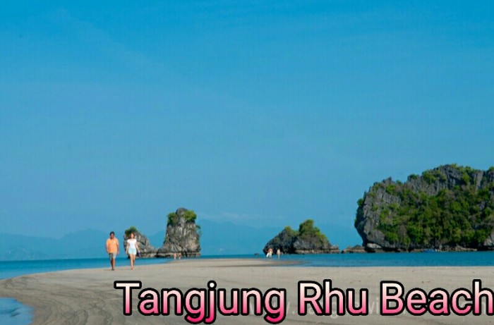
Tanjung Rhu Beach Langkawi
If you are looking for a secluded beach away from the crowd that offers breathtaking view of the emerald blue water and islands at a distance, then Tanjung Rhu is the beach to go. This is one our most favorite beaches when it comes to scenic settings. The beach is located at the north eastern edge of Langkawi at a remote corner.
The word Tanjung in Malay means a cape or a promontory, and Rhu stands for casuarina trees. So as the name suggests, you will see lots of casuarinas fringing the cape area and the beach.
If you approach the beach along the road Jalan Tanjung Rhu (#111), near the village Padang Lalang you will find a coastal road that goes all the way and ends at the public beach. The coastal road goes by the side of Tanjung Rhu Resort which has a private section on the beach. In fact when you reach the end of the coastal road and into the bay area, on the left you can see the private beach of the resort which is separated from the public beach by a fence.
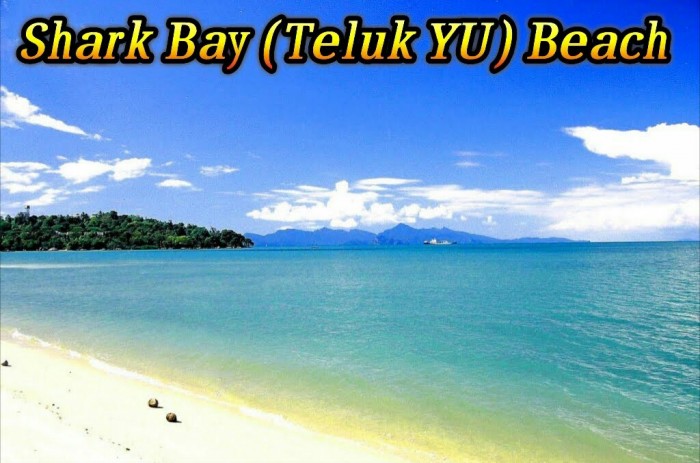
Shark Bay (Teluk Yu) Beach Langkawi
Shark Bay Beach is one of the most beautiful beaches in Langkawi and probably the most popular one with the tourists. Teluk in Malay means bay and Yu means Shark. But such name is given because of few sharks made of stone that are on display at one side of the beach promenade.
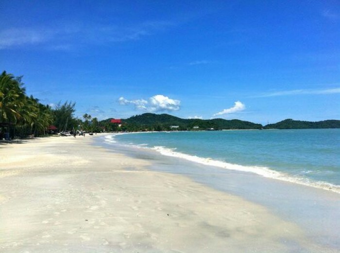
Pantai Cenang Beach Langkawi
If you fly into Langkawi, you can see the full stretch of this magnificent sandy beach below on your right as the aircraft gets close to the island for landing. Pantai Cenang beach is a 2km long stretch of white sand located on the western shoreline of Langkawi. This is the most popular public beach to both tourists and locals. Why?
Because this long beach with its gentle curve is the prettiest beach in the whole of Malaysia. With palms, coconut and other trees fringing the beach, it offers awesome view of the ocean and the islands close by. You can find all kinds of waterspout But Don't do activities From This Beach Unsafe , If our Guest Wanted to do Watersport we will assist guest to another which is safe and New waterspout.
